Boundary Mapping
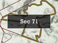
The maps below outline the boundaries for each of the whenua.
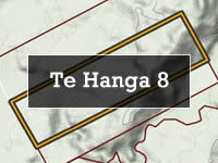

The maps below outline the boundaries for each of the whenua.
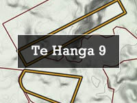
The maps below outline the boundaries for each of the whenua.

ArchSite is an online database that contains information about recorded archaeological sites in New Zealand. ArchSite uses GIS (Geographic Information System) technology to manage and display information on maps. It is the national inventory of archaeological sites in New Zealand.